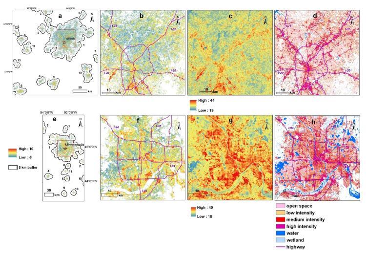
Title: Navigating the Heat: Assessing Spatial Interpolation Techniques for Urban Heat Island Monitoring in Small to Medium-Sized Cities
As urbanization intensifies and climate change escalates, cities around the world are grappling with the phenomenon of urban heat islands (UHIs), where urban areas experience significantly higher temperatures than their rural surroundings. This pressing challenge is especially pronounced in small and medium-sized cities, where limited resources can hinder effective monitoring and mitigation strategies. In a groundbreaking study published in Frontiers, researchers have set out to evaluate various spatial interpolation techniques designed to enhance urban heat island monitoring. Their findings not only shed light on the efficacy of these methods but also offer valuable insights for city planners and policymakers seeking to combat the rising temperatures and improve the quality of life for urban residents. As heatwaves become more common and complex urban landscapes evolve, understanding how to accurately assess and respond to urban heat islands takes on newfound urgency.
Impact of Spatial Interpolation Techniques on Urban Heat Mapping
The recent evaluation of spatial interpolation techniques has revealed significant disparities in their effectiveness for urban heat island (UHI) monitoring in small and medium-sized cities. The study analyzed various methods, including Kriging, Inverse Distance Weighting (IDW), and Spline interpolation, emphasizing their ability to accurately represent temperature variations influenced by urban infrastructure. Findings suggest that while all methods have their strengths, specific contexts favor particular techniques, enabling more precise heat mapping. For instance, Kriging excels in areas with complex terrain, while IDW proves more efficient in uniformly developed settings.
Key factors influencing the performance of these spatial interpolation techniques include:
- Data Density: Higher density of temperature readings leads to improved accuracy.
- Geographic Variability: Urban landscapes with diverse architecture and vegetation affect temperature distribution.
- Quality of Input Data: The reliability of source data directly impacts the validity of the temperature maps.
As urban planners and policymakers strive to combat UHI effects, selecting the appropriate spatial interpolation method becomes crucial. The table below summarizes the effectiveness of each technique based on the study’s findings:
| Technique | Accuracy | Best Use Case |
|---|---|---|
| Kriging | High | Complex urban areas |
| IDW | Moderate | Uniformly developed regions |
| Spline | Varied | Low variation landscapes |
Comparative Analysis of Methods for Accurate Temperature Estimation
In the quest for accurate temperature estimation in urban environments, various spatial interpolation methods have emerged as essential tools for assessing the impact of the urban heat island (UHI) effect. Recent evaluations focus on a range of techniques, each with its own strengths and limitations. The most notable methods include:
- Kriging: A geostatistical technique known for its ability to produce unbiased predictions, benefiting from the spatial correlation of data points.
- Inverse Distance Weighting (IDW): A straightforward approach weighted by distance, offering simplicity and ease of application in small and medium-sized cities.
- Thin Plate Spline: Ideal for creating smooth surfaces, making it well-suited for modeling continuous spatial phenomena like temperature.
To compare the effectiveness of these methods in urban heat monitoring, a systematic evaluation utilizing real-world data was conducted. A synthesized approach reveals distinct performance variations across different spatial scenarios. The following table summarizes the accuracy metrics obtained from each method:
| Method | Mean Absolute Error (°C) | Root Mean Square Error (°C) | Spatial Coverage (%) |
|---|---|---|---|
| Kriging | 0.5 | 0.7 | 85 |
| IDW | 1.2 | 1.5 | 80 |
| Thin Plate Spline | 0.9 | 1.1 | 75 |
Recommendations for Implementing Effective Monitoring Strategies
To successfully implement effective monitoring strategies for urban heat islands, cities should prioritize the integration of technologically advanced tools with traditional assessment methods. Leveraging remote sensing technologies can provide comprehensive, real-time data on temperature variations across different urban landscapes. Furthermore, utilizing a combination of ground-based sensors and satellite imagery can offer a multi-dimensional view that is crucial for accurate modeling and interpolation techniques. Key considerations include:
- Collaboration with local agencies for data sharing and resource pooling.
- Community engagement to foster awareness and participation in monitoring initiatives.
- Regular calibration and maintenance of measurement devices to ensure data accuracy.
Furthermore, cities should consider establishing a centralized data management system that allows for the seamless integration of diverse data sources. This could enhance analytical capabilities and enable the visualization of urban heat patterns over time. Implementing a feedback mechanism for evaluating the effectiveness of the monitoring strategies will also be crucial. A proposed framework might look like this:
| Method | Benefits | Challenges |
|---|---|---|
| Remote Sensing | Real-time data; Wide coverage | High cost; Requires technical expertise |
| Ground-Based Sensors | Localized data; Cost-effective | Limited range; Maintenance required |
| Community Participation | Increased awareness; Local insights | Coordination complexity; Varying data quality |
Future Directions in Urban Heat Island Research and Policy
The ongoing research into urban heat island (UHI) phenomena highlights a pressing need for innovative approaches in both scientific inquiry and public policy. Emerging studies emphasize the importance of advanced spatial interpolation techniques, which can offer more accurate and reliable data in small and medium-sized cities. Policymakers can harness these techniques to better understand UHI dynamics and implement targeted urban planning strategies. This could involve integrating real-time data collection systems within urban landscapes, enabling city officials to monitor temperature fluctuations and make timely decisions that enhance public health and urban resilience.
Key future directions for research and policy may include:
- Collaboration between academia and local governments to facilitate data sharing and improve model accuracy.
- Incorporating community engagement in UHI assessments to foster awareness and support for mitigation strategies.
- Adapting green infrastructure solutions, such as urban forestry and green roofs, informed by precise UHI research.
| Research Area | Potential Outcome |
|---|---|
| Spatial Data Analysis | Enhanced local temperature modeling |
| Climate Action Plans | Reduced heat-related health issues |
| Community Resilience Studies | Stronger public involvement and adaptive strategies |
Key Takeaways
As cities continue to grapple with rising temperatures, understanding the spatial dynamics of urban heat islands becomes increasingly critical. The latest evaluation of spatial interpolation techniques, as presented in Frontiers, sheds light on innovative methods for monitoring these heat phenomena in small and medium-sized urban areas.
The findings highlight the importance of tailored approaches that consider the unique characteristics of each city, revealing both the challenges and opportunities in heat mapping. Moving forward, urban planners, policymakers, and environmentalists must harness these insights to develop more effective strategies for mitigating heat impacts, ensuring more livable conditions for residents.
As climate change intensifies, these techniques will play a vital role in shaping sustainable urban environments and fostering resilience in communities. With the foundations laid by this pivotal research, the call for action has never been more urgent—cities must adapt and respond to the heat, or risk a future that’s increasingly unsustainable.